Never miss an update from Javier Montiel Bonmatí
Create your free account to connect with Javier Montiel Bonmatí and thousands of other innovative organizations and professionals worldwide
The technology developed by researchers at the University of Alicante allows the use of a smartphone to locate people injured in remote environments where there is no mobile phone coverage (GSM/UMTS). The smartphone emits a Wi-Fi signal that acts as a distress beacon and can reach a distance of several kilometers.
The system allows to locate exactly the injured and can be implemented on any Android smartphone model.
This technology is especially suitable for situations where there is no possibility of establishing communication using mobile phone networks and where speed in the rescue is essential to save lives. Two areas have been identified where the system can be vital: rescue of people in high mountain and sea rescue (man on the water).
TECHNICAL DESCRIPTION
In geographical areas where there is no coverage of the mobile phone service, the citizen does not have the possibility to establish any contact to request help with his smartphone.
However, it is possible, with the technology developed, to give any smartphone the ability to generate a distress signal. This signal informs the GNSS (GPS / Glonass / Galileo) location and is detectable several kilometers away.
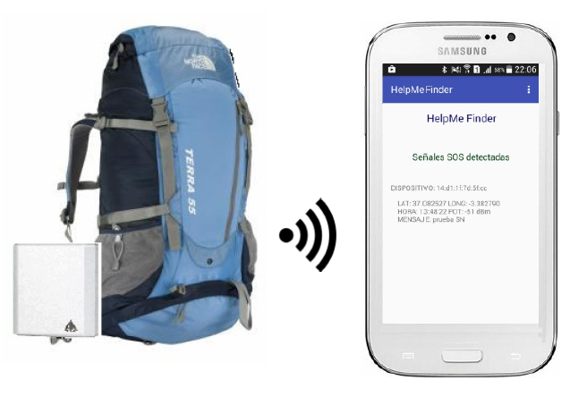
The technology developed consists of two fundamental elements, the software (App) incorporated in the emitting smartphone and a receiving device designed to receive and interpret the signal.
Thesmartphone must be equipped with a GNSS receiver and a Wi-Fi interface, elements found in almost all smartphones on the market. In addition, it must have installed an App, specifically designed by the researchers of the University, that emits the distress signal detectable by the receiving device. The developed App can be used by any smartphone that owns the Android operating system. Also, the App could be developed for other operating systems.
Thereceiving device used by rescue teams or mountain refuges, allows the signal to be detected several kilometers away, depending on the terrain orographic conditions and the physical characteristics of its antenna. The device has a small antenna and it connects to the rescuer's smartphone where the received signals are displayed.

When an incident occurs, the injured person only has to activate the App of the smartphone that will emit the signal periodically indicating the coordinates of his position.
Rescue teams equipped with the portable receiving device will perform their search operations with the advantage that they do not need to have visual contact with the injured person. At the moment they can detect a single signal, that will indicate the exact position of the injured, even if it is several kilometers away.
TECHNOLOGY ADVANTAGES
INNOVATIVE ASPECTS OF TECHONOLOGY
The main innovation of the technology is that it allows to use a standard device that we usually carry with us and provide it with specific functionality for emergencies.
The system facilitates the work of rescue teams, saving time and costs in rescue operations, and focusing on tracking in more specific areas.
In short, in extreme cases, it increases the chances of survival of the injured.
APPLICATIONS
This technology brings added value fundamentally in the following circumstances:
An area of specific application have been detected where this technology would be vital to save lives:high mountain rescue.
Frequently it happens that hikers who practice mountain sports suffer an accident or get lost. These people are usually equipped with a smartphone but there may be no mobile phone coverage.
In these cases the operative is to start their search when they are missing and a search is made based on the visual contact or sound signals. When there are extreme weather conditions, the chances of survival fall considerably and it is very difficult to locate people even if the rescue teams are close to the injured.
The technology developed allows to optimize the searching and reduce the tracking time. In situations with bad weather conditions (blizzard, fog) or even at night, it allows to locate a hiker with great precision.
CURRENT STATUS
The technology has been tested in high mountain simulating real cases with rescue teams. The tests performed have been very satisfactory, locating the injured in different locations, in a very short time. Those responsible for the rescue teams have been interested in being able to pilot tests in real conditions with hikers.
COLLABORATION SOUGHT
Companies interested in acquiring this technology for commercial exploitation through licensing agreement are required.
Ahead of the current Coronavirus outbreak, Innoget is fully committed to contributing to mobilizing scientific and expert communities to find a real solution to the Covid-19 pandemic. Therefore, we're supporting worldwide calls and programs that could help in any aspects of the coronavirus crisis.
Is your organization promoting or looking for innovation or research initiatives to mitigate the Covid-19 outbreak? Email us at covid19@innoget.com to list them.
Channeled through Innoget's online open innovation network, initiatives in the health, virology, medicine, or novel technologies applied to human health, among others, are listed and disseminated to Innoget members -ranging from hospitals, research institutes, scientists, businesses, and public administrations- and innovation partners worldwide.
Create your free account to connect with Javier Montiel Bonmatí and thousands of other innovative organizations and professionals worldwide
Send a request for information
to Javier
Technology Offers on Innoget are directly posted
and managed by its members as well as evaluation of requests for information. Innoget is the trusted open innovation and science network aimed at directly connect industry needs with professionals online.
Need help requesting additional information or have questions regarding this Technology Offer?
Contact Innoget support