Vision Dynamix - High precision, real-time 3D mapping system
Innovative Products and Technologies
Vision Dynamix is a hi-tech spin off company formed in 2016 on UKIM - FEIT with a purpose of developing a system for 3D mapping with high precision in real time.
Formed based on a project for the master thesis of Dushko Murtovski MSc. Using a single camera he developed a drone based system for Simultaneous Localization and Mapping (SLAM). Dushko is co-founder of Vision Dynamix. The thesis was developed by mentorship of Prof. Dr. Mile Stankovski who is the second co-founder.

TECHNOLOGY/PRODUCT OVERVIEW
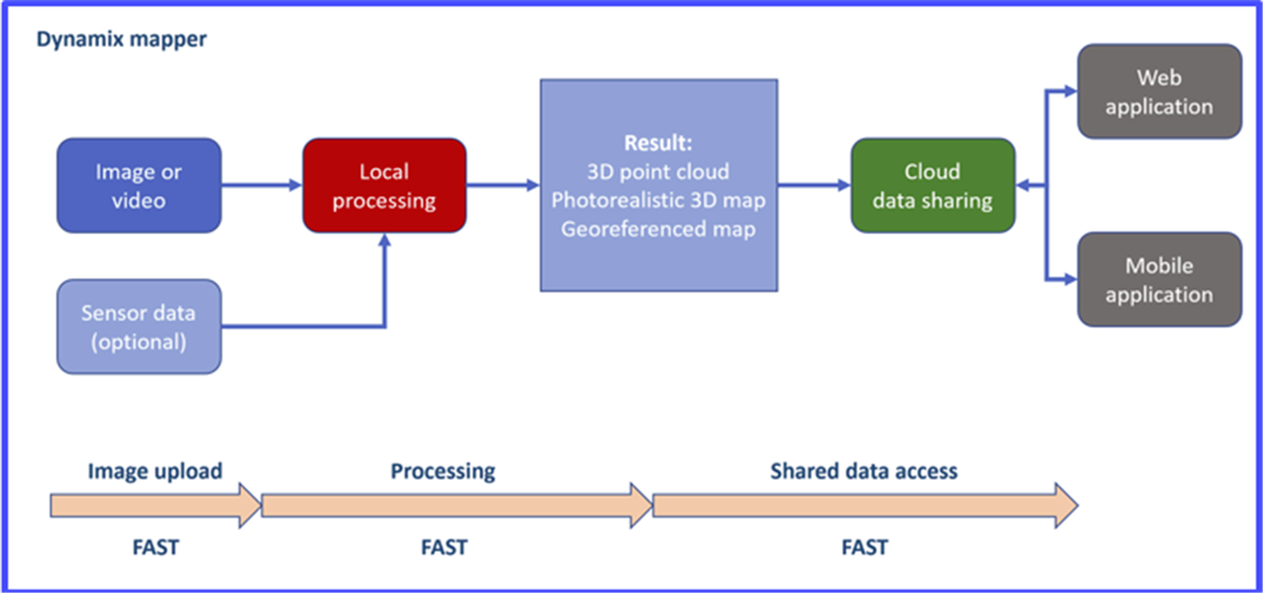
Dynamix Mapper - System for the creation of high-precision 3D maps
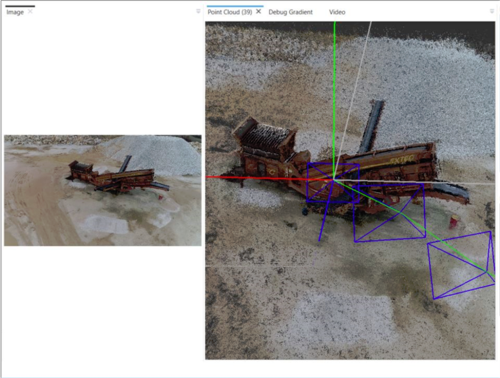
We are developing software based on state-of-the-art algorithm for Simultaneous Localization And Mapping, technique used in autonomous vehicles.
The product consists of:
We provide:
TECHNOLOGY/PRODUCT FEATURES, SPECIFICATIONS AND ADVANTAGES
The backbone of the solution is an algorithm for Simultaneous Localization and Mapping (known as SLAM). We use the whole video from the camera and not just separate images to create 3D maps. Current softwares are too slow and complicated. Competitors use LIDAR scanners which are expensive, require maintenance and specialized personnel. The output has no color and it requires complex software for data processing.
POTENTIAL APPLICATIONS
Our platform can be used in a variety of fields. Just imagine how much time and resources would be saved if a whole construction project is mapped. A process which normally takes days manually. Or that the environment is being mapped real-time while driving.
Current fields of application:
Future fields of application:
CUSTOMER BENEFITS
This technology has the power to cut significant costs in numerous fields of application from planning construction to archeology. The benefits of the environmentally friendly method gives the opportunity to further explore culturally and naturally valuable sights and resources, help us understand environmental catastrophes, accidents and even dangers of pollution.
TECHNOLOGY/PRODUCT READINESS LEVEL
The product is in beta stage and first customers are starting to use it. In the moment the focus is on domestic companies.
We are looking for:
Laser Consult Technical, Scientific and Economic Consulting Kft. (Ltd.) was established in 1992 with the objective of accompanying its clients from the innovational idea all the way to selling the intellectual product by providing complex innovational services.
Our mission, through our services, is to promote the utilisation of intellectual products, create a business value from innovative solutions, promote the co-operation of places of research and enterprises and the development of Hungarian higher education through the professional support of innovational activities. The foundation of the successful operation of the company is our fundamental philosophy, in which we lay a significant emphasis on establishing a relationship of confidence and developing a long-term successful co-operation with our clients.
Create your free account to connect with Peter Mogyorosi and thousands of other innovative organizations and professionals worldwide
Send a request for information
to Peter
Technology Offers on Innoget are directly posted
and managed by its members as well as evaluation of requests for information. Innoget is the trusted open innovation and science network aimed at directly connect industry needs with professionals online.
Need help requesting additional information or have questions regarding this Technology Offer?
Contact Innoget support